Parks Committee
About the Bryn Mawr Parks Committee
The Bryn Mawr Parks Committee serves as a liaison with our Park Commissioner and stays abreast of planning and events that would affect our neighborhood parks.
Meetings
The Parks Committee is currently meeting as a full committee on an as-needed basis. Check the Events calendar to stay caught up on the latest.
Bryn Mawr’s Green Spaces
Known locally as “a neighborhood within a park”, Bryn Mawr is bordered on all sides by parks and green space. These include Bassett Creek and Bassett Creek Park on the north, Bryn Mawr Meadows Park on the east, Theodore Wirth Park on the west and Cedar Lake along with the Kenilworth Corridor grassland area on the east and south.
Bassett’s Creek Park | 70.26 acres

The park is named for the creek that meanders from Medicine Lake in Plymouth through Golden Valley, Theodore Wirth Park and Minneapolis to the Mississippi River.
Features & Amenities
Biking Path | Playground/Tot Lot | Soccer Field | Softball Field | Sports Facility | Picnic Tables | Bike Racks | Tennis Court | Volleyball Court | Walking Path
Theodore Wirth Park | 740.29 acres

The park was named Theodore Wirth Park on September 7, 1938. Wirth was an advocate of playgrounds for children in parks and took the lead in creating the first playgrounds in Minneapolis parks. Wirth is best known, however, for reshaping the city’s lakeshores and building its parkways.
Features & Amenities
Archery | Beach | Biking Path | Cross-Country Ski Trail | Decorative Fountain | Disc Golf Course | Drinking Fountain | Fishing Pier | Garden | Golf Course | Hiking | Mountain Biking | Pay Parking Lot | Picnic Area | Playground/Tot Lot | Restroom Facility | Sledding/Tubing | Snowboarding | Snowshoeing | Soccer Field | Tennis Court | Walking Path | Water Pump | Well
Bryn Mawr Meadows | 51.56 acres

The neighborhood and the park named Bryn Mawr take their names from John Oswald’s farm that once occupied that region of the city. Bryn Mawr means “great hill” in Welsh.
Features & Amenities
Biking Path | Cricket Field | Drinking Fountain | Grill | Picnic Area | Playground/Tot Lot | Restroom Facility | Soccer Field | Softball Field | Sports Facility | Tennis Court | Wading Pool | Walking Path
Eloise Butler Wildflower Garden & Bird Sanctuary | 15 acres

The Eloise Butler Wildflower Garden, the oldest public wildflower garden in the country, is right on the border of the neighborhood and it’s back gate can be reached by a short walk through a small woods from the neighborhoods northwest boundary. Self guided tours can be accessed here. The narrow, winding trails of the Garden lead you through a variety of habitats in hilly terrain.
Peak Display Times
April and May (Woodland): Bloodroot, wild ginger, trillium, bluebells, trout lilies
June and July (Wetland): Showy lady’s-slippers, native irises, cardinal flowers
Mid-to Late-Summer (Meadow): Asters, sunflowers, blazing stars, goldenrods
Fall (throughout): Late-season flowers and autumn leaves
The garden is home to more than 600 plant species and 130 bird species.
Reserve Block 40 Park | 1.67 acres

The park has always been referred to by its designation on plat maps in a neighborhood known as McNair Park. The park has never been officially named.
Features & Amenities
Picnic Area | Playground | Tot Lot
Waterways
The neighborhood is also within walking distance of a number of beautiful, inner-city lakes – Brownie Lake, Cedar Lake, and Wirth Lake.

Brownie Lake | 27.66 acres
Brownie Lake is the smallest and northernmost link in the Chain of Lakes.
Features & Amenities
Biking Path | Walking Path | Canoe & Kayak Accessible | Canoe Launch & Rack
Photo Credit: Eswanner, CC BY-SA 4.0 <https://creativecommons.org/licenses/by-sa/4.0>, via Wikimedia Commons
Cedar Lake | 288.1 acres

The lake offers ample shore fishing opportunities; the West side fishing pier is a great spot for catching northern pike, muskie and bass.
Features & Amenities
Biking Path | Cross-Country Ski Trail | Fishing Pier | Grill | Pay Parking Lot | Picnic Area | Walking Path | Well
Photo Credit: AlexiusHoratius, CC BY-SA 3.0 <https://creativecommons.org/licenses/by-sa/3.0>, via Wikimedia Commons
The park is named for the creek that meanders from Medicine Lake in Plymouth through Golden Valley, Theodore Wirth Park and Minneapolis to the Mississippi River.
Features & Amenities
Beach | Dressing Rooms | Drinking Fountain | Fishing Pier | Floating Swim Dock | Picnic Area (non-reservable) | Playground/Tot Lot | Restroom Facility | Volleyball Court – Sand | Walking Path | Free Parking Lot
Photo Credit: Minneapolis Parks & Recreation Board

Wirth Lake
Basset Creek | 24,900 acres

The creek’s Dakota name is Ȟaȟá Wakpádaŋ, which can be loosely translated as “Falls Creek.”
Features & Amenities
Canoe & Kayak Accessible | Access the Interactive Paddling Map
Photo Credit: edkohler, CC BY 2.0 <https://creativecommons.org/licenses/by/2.0>, via Wikimedia Commons
Bike Trails & Walking Paths
Within our parks, green spaces, and adjacent parkways, the neighborhood is also blessed with a confluence of bicycle trails and walking paths
Visit Explore Minnesota for detailed maps.
Luce Line Trail | 63 miles | Crushed Limestone | Paved
The Luce Line Trail is a commuter biking trail that runs along Bassett Creek. It passes through Theodore Wirth Park to the West, and eventually reaches the city of Cosmos in west-central Minnesota. Going Southeast, the trail connects to nearby Bryn Mawr Park where the Cedar Lake Trail also meets. The Cedar Lake Trail travels from Hopkins to downtown Minneapolis.
Trail Uses
Hiking | Biking | Mountain Biking | Horseback | Snowmobiling | Accessible Outdoors
North Cedar Lake Regional Trail | 4.4 miles | Paved
The Cedar Lake Regional Trail which will take you through Hopkins and down into Eden Prairie to the southwest and to downtown Minneapolis and the Mississippi to the northeast
Trail Uses
Hiking | Biking
Kenilworth Trail | 1.5 miles | Paved
The Kenilworth Trail will take you past the east side of Cedar Lake and connects to the North Cedar Lake Trail to Eden Prairie.
Trail Uses
Biking
Grand Rounds Trail | 51-miles | Paved
The Grand Rounds trail is adjacent to Theodore Wirth Parkway and will take you north to Victory Parkway and South to the Chain of Lakes.
Trail Uses
Walking | Biking
Current Parks Projects
Cedar Lake - Lake of the Isles Master Plan
The Minneapolis Park Board is in the middle of creating 25-year plans for all of its parks. Most Bryn Mawr parks are included in their North Service Area. The BMNA has representatives on this project, which includes the Bryn Mawr Meadows and Bassett Creek Park.
Related Links – North Service Area Master Plan
The Cedar Lake-Lake of the Isles Master Plan (Cedar-Isles Master Plan) will guide improvements and stewardship at Cedar Lake, Lake of the Isles and surrounding parkland, parkways and trails for the next 20+ years.
New Virtual Walking Tours Debut for Cedar-Isles Master Plan
Tours provide information on the features and history of the two lakes for long-term planning effort Check out new virtual walking tours created for the Cedar-Isles Master Plan! Whisk around the two lakes from the comfort of your home or follow along in-person on your phone or tablet. There are 10 virtual experiences sorted by geography chock full of fascinating history and facts about the two lakes.
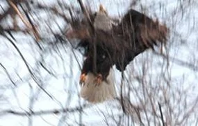
Wildlife Watch
-
![]()
March 7, 2013 - Cedar Lake Road Photo courtesy of Ron Johnson
-
![]()
March 7, 2013 - Cedar Lake Road Photo courtesy of Ron Johnson
-
![]()
March 7, 2013 - Cedar Lake Road Photo courtesy of Ron Johnson